About the Geography of Guatemala
Capital : Guatemala.
Area: 108 930 km²
Borders : With Mexico (1,684 km) and Belize (266 km) to the North, Honduras (256 km) and El Salvador (203 km) to the South.

Coasts: 250 km of Pacific coastline to the West and 150 km of coastline the Caribbean Sea to the East.
Highest Point: Tajumulco volcano (4,220 meters above sea level)
Time difference: Guatemala is on Central Standard Time (CST). The country does not adhere daylight savings time. Guatemala is six hours behind Greenwich Mean Time (GMT).
Currency: 1 euro = 8,55 Quetzales ; 1 USD =7,74 Quetzales
Cities: Guatemala City is the main city in the country, with 1 million inhabitants. Urban areas includes Mixco, Villa Nueva, which exceed 4 million inhabitants. The other main cities of the country are Quetzaltenango (150,000), San Juan Sacatepéquez (140,000).
Regions: see our article on the landmarks of Guatemala
Population of Guatemala

Population: 17,5 million
Density: 155 inhabitants / km2
Life expectancy: 72.5 years
Birth Rate: 2,90 children
Rural Population: 50%
Literacy Rate: 80%
Modern Guatemala: politics and society
Guatemala is Central America’s most populous country – With over 17 million inhabitants, it has more people than all other Central American countries except Mexico. The population is young, with a median age of just 23 years.
The country gained independence in 1821 – Guatemala was part of the Spanish colonial empire for 300 years before joining the short-lived Federal Republic of Central America, then becoming fully independent in 1838.
Guatemala City is the largest city in Central America – The metropolitan area houses over 5 million people, making it a major regional hub for business, culture, and transportation.
Ethnic composition : 60% “mestizo” (Indian-European), 38% Indian of Mayan origin, 2% Garifuna. K’iche (9%) and Cakchiquel (8%), among other Mayan indigenous populations.
Languages: Spanish is the only official language in the country (60%), but it is not spoken by all ethnic groups. There are 20 languages of Mayan origin, especially spoken on the plateau and in rural areas. The most common are K’iche ’, Cakchiquel, and Q’eqchi, which bring together nearly 3 million speakers. Garifuna, African Caribbean origin, is spoken on the Caribbean coast, and Xinca of non-Mayan Native American origin is spoken in the southeast of the country.
Guatemalan Politics
Regime: Democratic. The president is elected for 4 years, he is both the head of state and government. Alejandro Giammattei was elected president in January 2020.
National holidays: September 15. It is celebrated the proclamation of independence of Central America.

National Flag and Emblem: in the foreground is the Quetzal bird, a symbol of freedom, and a scroll representing the independence of Central America from Spain. In the background, two rifles remind the defense of the country, and two crossed swords symbolize honor. The whole is framed by a laurel wreath representing victory.
Religion : Guatemala has no official religion. The population is 50% Catholic, 40% Protestant, 10% other. Protestantism is in the process of becoming the majority, especially in rural areas. There is also the largest Orthodox community in Latin America made up of 300,000 people. Christianity remains strongly imbued with ancestral indigenous practices.
Economic facts

With a GDP of nearly $70 billion USD, Guatemala is the largest economy in Central America. The country has experienced solid growth for ten years (approx. + 4% per year).
Economic and agricultural facts
Guatemala is the world’s leading cardamom producer – This aromatic spice, essential in Middle Eastern and Indian cooking, generates significant export revenue for the country. Guatemala produces about 80% of the world’s cardamom supply.
Coffee from Guatemala is among the world’s finest – The volcanic soil and high altitudes (4,000-6,000 feet) create perfect conditions for growing Arabica coffee. Antigua coffee is particularly prized for its full body and spicy, smoky flavor.
Agriculture employs nearly half the workforce – Beyond coffee and cardamom, Guatemala exports significant quantities of sugar, bananas, and vegetables. The fertile volcanic soil makes the country incredibly productive for farming.
The agricultural sector is the most important economic activity, accounting for almost a quarter of GDP and 75% of national exports. Guatemala produces notably coffee, bananas, sugar, corn. It is also the world’s leading exporter of nutmeg. Tourism is also a fundamental source of currency and has great development potential.

All about Guatemala
Guatemala is a Central American country with a rich history and diverse landscapes. Home to ancient Maya sites, active volcanoes, and vibrant indigenous cultures, Guatemala offers visitors a unique mix of historical sites and natural attractions. Here are key facts about Guatemala that provide useful context for understanding this fascinating destination.
Geographic wonders and natural facts
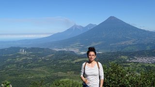
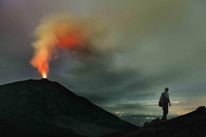
Guatemala is surprisingly mountainous – Despite its compact size (roughly the size of Tennessee), Guatemala contains 37 volcanoes, with 3 still active. The country sits where three tectonic plates meet, creating this dramatic volcanic landscape.
Lake Atitlán is impossibly deep – Often called the world’s most beautiful lake, Atitlán plunges to depths of over 1,000 feet, making it one of the deepest lakes in Central America. It was formed in a massive volcanic crater 84,000 years ago.
Guatemala has 14 distinct ecosystems – From cloud forests to mangrove swamps, this small country packs incredible biodiversity into just 42,000 square miles. You can experience tropical rainforests, highland pine forests, and coastal wetlands all in one trip.

Cultural and historical information
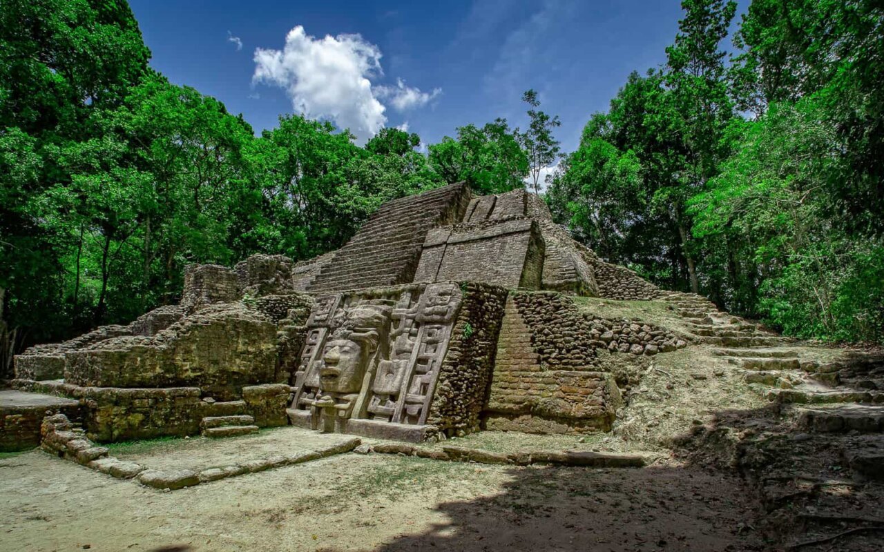
The Maya civilization thrived here for over 2,000 years – Guatemala was the heartland of the ancient Maya, with Tikal being one of their largest cities. At its peak around 800 AD, Tikal housed over 100,000 people and featured pyramids reaching 200 feet high.
Guatemala City sits on a plateau 4,897 feet above sea level – This makes it one of the highest capital cities in Central America, contributing to its spring-like climate year-round despite being near the equator.
Spanish is the official language, but 22 Maya languages are still spoken – Over 40% of Guatemala’s population is indigenous, making it one of the most culturally diverse countries in Latin America. Each Maya community maintains its distinct language, traditions, and colorful textile patterns.

Unique distinctions
Guatemala has the steepest highway in Central America – The road from Guatemala City to Antigua features gradients that will test any driver’s nerves, climbing from sea level to over 5,000 feet in just a few hours.
The quetzal bird gives its name to Guatemala’s currency – This stunning bird, with its brilliant green feathers and long tail, is Guatemala’s national symbol. Ancient Maya considered quetzal feathers more valuable than gold.
Guatemala celebrates the largest Holy Week processions in the Americas – During Semana Santa (Easter week), Antigua’s streets fill with elaborate processions featuring massive floats carried by hundreds of participants, some weighing over 7,000 pounds.
Planning your Guatemala adventure
The dry season (November-April) offers perfect weather – Temperatures stay comfortable year-round due to the high altitude, but the dry season provides the clearest skies for volcano viewing and outdoor activities.
You can visit multiple ecosystems in a single day – Guatemala’s compact size means you can experience cloud forests in the morning and tropical beaches by afternoon, making it perfect for diverse adventures.
Tourism infrastructure is well-developed – From luxury eco-lodges to budget hostels, Guatemala offers accommodations for every type of traveler, with English widely spoken in tourist areas.
Our local travel experts at Terra Guatemala can craft the perfect itinerary for you. Contact us at : contact@terra-guatemala.com or ask for a quote.