Key facts: 300 volcanic structures in Guatemala, including 37 recognized volcanoes and 3 active ones accessible on foot.
Main volcanoes featured:
Pacaya (active) – The most accessible from Antigua, easy 2-hour hike, suitable for children, altitude 2,500m. Allows observation of fumaroles and sometimes lava flows.
Fuego (most active) – 3,763m, in constant activity with violent eruptions. Last major eruption in June 2018. Visited from the neighboring Acatenango volcano.
Acatenango – 3,976m, 2-day ascent with overnight camping. Spectacular views of erupting Fuego, Pacaya, Agua, and Lake Atitlán. Requires good physical condition (1,400m elevation gain).
San Pedro – 3,020m, overlooks Lake Atitlán. 3-hour ascent, 1,100m elevation gain, moderate difficulty. Possible to sleep at the summit for sunrise.
Recommendations: Good physical condition required, supervision necessary, beware of altitude sickness. Guatemala is considered THE best destination in the world for observing volcanic eruptions.
How many volcanoes are in Guatemala?
Guatemala is crossed by a large chain of volcanoes, some of which are active. Between Mexico in the north and the Honduras and Salvador to the south, there are no less than 300 volcanic structures, of which 37 are recognized as volcanoes. Three of them are active today and can be approached by foot during a trekking trip.
Hiking and trekking to discover Guatemalan volcanoes
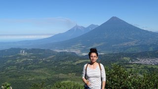
Their imposing silhouettes follow us for a throughout part of the journey, overlooking the high plains, Lake Atitlan and the colonial cities. They offer a rich playground for lovers of hiking, mountain biking and all kinds of sporting activities.
Guatemala is considered the best destination for observing volcanic eruptions. The fumaroles, lava flows, even explosions create special memories.
Recommandations before hiking a volcano
There are volcanoes of all sizes in Guatemala. It is recommended to be in good physical condition to start a climb. You should also be well supervised and pay attention to altitude sickness (also known as MAM: mountain sickness).
Our Volcano Tour itineraries

Volcano Tour in Guatemala

Adventure tour: a Journey Down Volcano Road in Guatemala

Panorama of Guatemala : must-see tour in 2 weeks

Adventure Tour 2 weeks in Guatemala

Wonders of Guatemala Tour
The most famous volcanoes in Guatemala
Pacaya volcano : one of 3 active volvanoes
Pacaya is one of three active volcanoes in Guatemala. Its proximity to the colonial city of Antigua and its easiness of access make it one of the most appreciated by travelers. We recommend leaving early in the morning to enjoy an unobstructed view. The excursion is suitable for children: the walk lasts approximately 2 hours, the descent is 400 meters reaching altitude of 2,500 meters.
Panoramic views on Agua, Acatenango and Fuego volcanoes
Take in the views of the volcanoes Agua, Acatenango and Fuego in the distance. Fuego,regularly experiences erruptions. The last eruption of Pacaya volcano dates back to March 2014. During these periods of activity, it is possible to approach a few meters from the lava flows. Out of eruption, long fumaroles can be observed accompanied by a distinctive hissing sound.
Fuego Volcano
The most active volcano in Guatemala
At 3,763 meters high, Fuego is one of the most active volcanoes in Central America! Its indigenous name “Chi’gag” means “where is the fire” in Maya Cakchiquel . It is in constant activity and it’s eruptions are violent! More than 10,000 people were evacuated as a precaution during the 2012 eruption. The last big eruption recent dates back to June 2018.
Great view from Acatenango
You can appreciate the view of Fuego volcano in the distance from the city of Antigua, or during the ascent up the Pacaya… But the best way to enjoy the “Chi’gag” is to climb the nearby Acatenango volcano to enjoy the spectacle!
Note: Though Fuego is one of the most active volcanoes in the world, it can still have breaks of one or two weeks during which its activity is limited.

Acatenango V0lcano
A volcano just a short distance from Antigua
is located just near the Fuego, a stone’s throw from Antigua. From the top of its 3,976 meters, you can see its neighbor Fuego in full activity, the Pacaya and Agua volcanoes, as well as Lake Atitlán. The climb requires a good physical condition.
Two day ascension to Acatenango
The expedition is organized in two days with overnight stay in a tent. The first day is challenging with 1,400 meters of elevation to climb (about 5-6 hours of walking). As you approach base camp, you can hear the exploding Fuego explosions. We will listen to the giant roar all night, the roar of the blasts vibrate up the sides of the volcano. In clear weather, lava flows illuminate the landscape. We never tire of the spectacle! The next day, 2 hours of additional hiking will be necessary to reach the summit and enjoy a panoramic view before returning to Antigua.

San Pedro Volcano
A volcano on the banks of Lake Atitlan
San Pedro is one of the volcanoes bordering Lake Atitlán. The approach can be done by tuktuk from the villages of San Pedro La Laguna and San Pedro Atitlán. The 1,100 meters in elevation require good physical condition, but do not present any technical difficulties.
A moderately easy trek to the top
From the entrance to the park, it takes 3 hours to reach the highest point at 3,020 meters. The trail first crosses fields of corn and coffee before entering the jungle. The summit offers a breathtaking view of the lake and Santiago de Atitlán. On the horizon, the Nariz del Indio or “Indian Nose” mountain draws a face in human form. It is possible to sleep in a refuge near the summit to enjoy the sunrise on Lake Atitlán.
About the author
Tristan Reger, founder and manager of Terra Guatemala since 2018, specializes in Guatemalan volcanoes and adventure tours. Passionate about the country’s natural sites, he has accompanied travelers in discovering Guatemala’s most spectacular landscapes.
Learn more about Tristan and our team → https://terra-guatemala.com/blog/local-experts/tristan