Update: Fuego volcano activity (5 August 2026). The eruption of the Fuego volcano is over. INSIVUMEH announced the end of the eruptive phase after roughly 50 hours of activity. People evacuated from Escuintla and Sacatepéquez have begun returning home.
The episode began during the night of 3 August 2026, when the authorities declared a national orange alert. Pyroclastic flows travelled down the Seca and Ceniza ravines. Ash dispersed to the west and north-west, as far as 120 kilometres. Evacuations took place in El Porvenir, Las Lajitas and Morelia.
Some caution is still advised. Because of the rains, INSIVUMEH reports a low to moderate risk of lahars in the Seca and Ceniza ravines. Ascents had been suspended during the episode. If you are planning the Acatenango or Fuego trek, check that the trails have reopened with INSIVUMEH and CONRED before you leave.
Sources: INSIVUMEH (special volcanic bulletins BEFGO-064-2026 and BEFGO-065-2026) and CONRED. Situation as of 5 August 2026, subject to change.
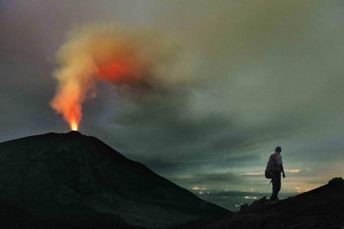
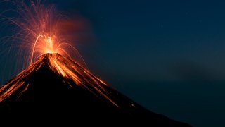
4:30 a.m. The first rumblings pull you from sleep in your refuge on the Acatenango volcano. Facing you, less than 8 kilometres away, the Volcán de Fuego hurls its glowing bombs into the Guatemalan darkness. The ground shakes beneath your feet. The air smells of sulphur.
This is the only place in the world where you can watch a volcano in permanent eruption without risking your life.
Fuego is not a volcano like the others. Since 2002, it has erupted every 15 minutes, day and night, without pause. The people of Antigua set their clocks by its rumbles. Airline pilots steer around its ash plume, which rises 6,000 metres high. Geologists from around the world come here to study this singular natural laboratory.
Unlike the dormant volcanoes you “visit”, Fuego is something you experience. You do not climb to its summit. You watch it, you listen to it, you feel it vibrate in your chest. This adventure places you before a force few humans have ever contemplated: the Earth in permanent creation.
No summit selfies here, no run-of-the-mill hikes. Just you, the Guatemalan night, and a giant of fire that has been sculpting the landscape for millennia. An experience that will define your Guatemalan adventure and your discovery of its volcanoes.

The Fuego volcano in brief
Portrait of a living giant
Fuego rises to 3,763 metres, just 35 kilometres from Antigua Guatemala. This 230,000-year-old stratovolcano has maintained near-permanent eruptive activity since 2002, something unique in the world. Its Maya name, K’ahb, means “the one who spits fire”, a description the Spanish conquistadors translated as “Volcán de Fuego” as early as their arrival in 1524.
Formation: when the earth tells its story
Fuego belongs to the Central American volcanic arc, born from the collision of two titanic forces. The oceanic Cocos plate dives beneath the continental Caribbean plate at a speed of 7 centimetres per year. This subduction creates magma chambers 150 kilometres deep, feeding the volcano over millennia.
Fuego forms a striking volcanic complex with its neighbours Acatenango and Yepocapa. These three giants share the same geological origin but behave in radically different ways: Acatenango has slept since 1972, Yepocapa has been dormant for centuries, while Fuego erupts relentlessly. The difference comes down to the chemical composition of their magma and the depth of their feeding conduits.
Type of volcano: an explosive stratovolcano
Fuego shows the classic structure of a stratovolcano: a cone 1,200 metres high, built by 230,000 years of successive eruptions. Its slopes, inclined at 35 to 40 degrees, alternate layers of solidified lava and ash deposits, creating the perfect conical silhouette seen from Antigua.
Its andesitic magma contains 58% silica, a composition that explains its explosive character. At 1,000°C during eruptions, this viscous lava does not flow gently as in Hawaii but explodes violently on contact with pressurised gases. The main crater, 150 metres across, constantly changes depth depending on the intensity of the activity.
Constant activity
Fuego produces near-continuous Strombolian explosions with clockwork regularity. During quiet periods, explosions occur every 15 to 20 minutes. During active periods, the interval drops to 3 to 5 minutes. Each explosion throws glowing volcanic bombs up to 300 metres high, falling within a 500-metre radius of the crater.
On average the volcano ejects 10,000 cubic metres of material per day. Its ash plume rises to 6,000 metres, visible from Guatemala City, 120 kilometres away. The rumbles reach 70 decibels and carry up to 6 kilometres. Pyroclastic flows, those clouds of gas and ash at 600°C, race down the slopes at 100 to 150 km/h during major eruptions.
Activity cycles: understanding Fuego’s rhythms
Fuego alternates between several distinct phases. Background activity consists of regular explosions every 15 to 20 minutes. Paroxysms, intense eruptions lasting 2 to 6 hours, occur 3 to 4 times a month. Major eruptive phases can bring several days of heightened activity. The volcano releases lava flows 2 to 3 times a year, stretching 1 to 3 kilometres depending on intensity.
Its place in Guatemala’s volcanic history
Pedro de Alvarado and his conquistadors documented Fuego’s first recorded eruption in 1524. Since then, more than 60 major eruptions have been recorded. The historic 1974 eruption lasted 6 continuous days, sending ash as far as Mexico. The June 2018 disaster remains etched in memory: pyroclastic flows destroyed the village of El Rodeo, causing 215 deaths.
Modern monitoring began in 1922 with the installation of a permanent seismic station. Today, INSIVUMEH (the national institute for volcanic monitoring) has maintained a network of 8 cameras since 2010, installed 15 kilometres from the crater. The alert level remains permanently orange on the green-yellow-orange-red scale.
Observing the Fuego volcano safely
- Safe distance: at least 8 kilometres (the summit of Acatenango).
- Best visibility: between 6 p.m. and 6 a.m.
- Recommended season: November to April (clear skies).
- Weather constraint: clouds cling to the summit from around 2 p.m. in the wet season.


What makes this experience unique
Fuego offers a volcanic experience that few places on Earth allow. Unlike the dormant volcanoes you climb, Fuego is meant to be watched. It is one of only five volcanoes in the world in permanent eruption, alongside Etna, Stromboli, Yasur and Erta Ale. This constancy lets you observe geological formation in real time: each explosion adds a new layer to the volcanic edifice, sculpting the landscape before your eyes.
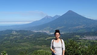
From the summit of Acatenango, the panorama takes in the entire Guatemalan volcanic range. To the west, Tajumulco rises to 4,220 metres. To the south, the Santa María and Santiaguito volcanoes smoke quietly. This rare vantage point reveals the scale of the Central American volcanic arc, the product of millions of years of tectonics.
The volcanic ecosystem is home to species adapted to extreme conditions. Epiphytic bromeliads filter moisture from the ash-laden clouds. Ayacahuite pines withstand the acidic soils. Coatis forage across the cooled lava flows in search of insects. This specialised biodiversity reflects life’s capacity to adapt to geological forces.
The communities living at the foot of Fuego have a pragmatic relationship with the volcano. Farmers in Alotenango make the most of the fertile volcanic soils for their coffee and avocado crops. Families in La Democracia have developed well-drilled evacuation protocols, passed down from one generation to the next. These residents do not “live in harmony” with the volcano; they coexist with a permanent threat they know intimately. Their accounts reveal a relationship built on respect, vigilance and daily adaptation to an unpredictable environment.
Discovering Fuego: your exploration options
For contemplative adventurers: the Acatenango ascent, the ultimate viewpoint
Watching Fuego from the summit of Acatenango remains the most striking and the safest experience. This 2-day, 1-night trek takes you to 3,976 metres, facing the permanent theatre of eruptions. The climb begins at La Soledad (2,400 m) and rises through three distinct ecosystems: tropical forest, cloud forest, then alpine vegetation.
The moderate-to-difficult level calls for reasonable fitness. The 1,576-metre ascent spreads over 6 to 8 hours depending on your pace. The summit camp, between 3,700 and 3,976 metres, brings night-time temperatures down to -5°C. Bring a sleeping bag suited to these high-altitude conditions.
The show truly begins at nightfall. From 6 p.m., Fuego’s glowing projections become visible, setting the Guatemalan sky ablaze in orange. Explosions every 15 minutes punctuate an unforgettable night. Dawn reveals the full panorama: the Pacific Ocean to the south, the Santa María and Tajumulco volcanoes to the west, Guatemala City to the north-east. This ascent is at the heart of our Volcano Tour in Guatemala.
For experienced explorers: a closer approach in specialised observation zones
Experienced adventurers can get closer to Fuego through specialised observation zones, located between 3 and 5 kilometres from the active crater. These expeditions cannot be improvised: they require the guidance of volcanologist guides certified by INSIVUMEH and complete personal protective equipment.
The approach starts from Finca El Porvenir, on the western flank of the volcano. Guides continuously assess volcanic activity by radio with the observatory. Helmets, filter masks and gas dosimeters are part of the mandatory equipment. This proximity lets you observe the details of eruptive mechanisms: the formation of volcanic bombs, the dynamics of ash plumes, pyroclastic flows in the ravines.
The experience is intended for adventurers who already have significant volcanic experience. Conditions change quickly: winds pushing gases towards the observation zones, sudden intensification of activity, volcanic bombs falling beyond the usual perimeter. Flexibility and acceptance of safety constraints are essential to living this exceptional immersion. Explore all our hiking and adventure tours to build your trip around it.